Lauterbrunnen Hikes: The Best Walks from the Valley Floor to the Panorama Trail
The best hikes around Lauterbrunnen fall into three groups: the flat path along the valley floor from Lauterbrunnen to Stechelberg (2–3 hours, fine with a pram), the terrace walks on the Mürren side such as Grütschalp to Mürren (about 1 hour 15 minutes) and the Mountain View Trail (about 2 hours), and the high trails on the Wengen side, above all the Panorama Trail from Männlichen to Kleine Scheidegg (4.5 km, about 1 hour 20 minutes). Add the long walk into the head of the valley to Obersteinberg, and the via ferrata from Mürren down to Gimmelwald for those with a head for heights, and you have a week of walking without repeating a path.
This guide sets out each walk with the distances and times published by the local tourist boards and lift operators, explains how the lifts let you walk downhill rather than up, and helps you match a route to your fitness, the weather and the season.
How walking works in this valley
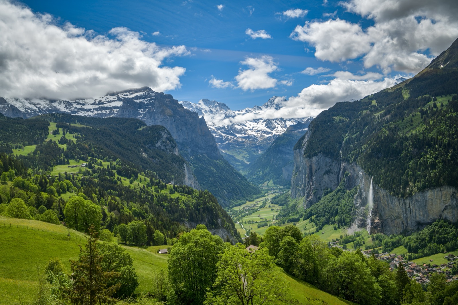
The Lauterbrunnen valley is a deep glacial trough: a flat green floor at about 795 m, cliffs rising almost sheer on both sides, and a terrace on top of each cliff. That shape decides almost every walk.
- The valley floor is flat, easy and lined with waterfalls. It is the place for a gentle day, a walk with children or a wet morning.
- The terraces hold Mürren and Gimmelwald on the west side and Wengen on the east. Lifts climb the cliffs, so you can start a walk high up without the climb.
- The high ridges above Wengen, from Männlichen to Kleine Scheidegg, sit at over 2,000 m with the Eiger, Mönch and Jungfrau straight ahead.
The trick that local walkers use is simple: ride up, walk across or down. Almost every good walk in this guide starts at a lift station and ends at another one or back on the valley floor.
Lauterbrunnen Tourism’s own advice is to check the status of lifts and footpaths before you set off; both pages are updated daily and paths high up can close after snow or storms.
The walks at a glance
| Walk | Side | Distance / time | Effort |
|---|---|---|---|
| Lauterbrunnen to Stechelberg along the valley | Valley floor | 2–3 hours | Easy, flat, pram-friendly |
| Lauterbrunnen to the Trümmelbach falls | Valley floor | About 5 km, about 1 hour | Easy |
| Legend Trail, Sandbach to Rütti | Head of the valley | 3.9 km, about 70 minutes | Easy |
| Grütschalp to Mürren | Mürren side | About 1 hour 15 minutes | Easy, gently uphill |
| Mountain View Trail to the Allmendhubel | Mürren side | About 2 hours | Moderate |
| North Face Trail via the Schiltalp | Mürren side | Half a day | Moderate |
| Gimmelwald into the Sefinental | Mürren side | Around 10 km | Moderate |
| Stechelberg to Obersteinberg | Head of the valley | About 2 hours up | Strenuous |
| Panorama Trail, Männlichen to Kleine Scheidegg | Wengen side | 4.5 km, about 1 hour 20 minutes | Easy to moderate |
| Männlichen to Wengen | Wengen side | Long descent | Moderate on the knees |
| Wengen via Wengwald to Lauterbrunnen | Wengen side | Almost 500 m down | Moderate, steep in places |
| Eiger Trail, Eigergletscher to Alpiglen | Above Kleine Scheidegg | 6.1 km, about 2 hours | Moderate |
| Via ferrata, Mürren to Gimmelwald | Mürren side | 2.2 km | Fairly difficult (K3), equipment needed |
On the valley floor: Lauterbrunnen to Stechelberg
This is the walk everyone should do once, and the one to save for a cloudy day when the terraces are lost in mist.
Switzerland Tourism describes the valley path from Lauterbrunnen to Stechelberg as flat, mostly suitable for prams, and 2–3 hours long. It runs through meadows and past farms, with information boards about the valley’s 72 waterfalls. You pass below the Staubbach falls, which drop about 297 metres from the cliff next to the village, and at the far end come close to the Mürrenbach falls pouring down the Mürrenfluh near Stechelberg.
Practical points:
- Shortening it. PostBus route 141 runs along the valley road to Stechelberg, so you can walk one way and take the bus back. The tourist board recommends buying the ticket before you board, at the machine at Lauterbrunnen station or in the SBB Mobile app, because the buses are often very full.
- Cycling it. If you hire a bike, the tourist board advises using the old Stechelberg road rather than the main road, which is narrow and carries traffic at up to 80 km/h.
- Toilets. There are public toilets at the station, the church car park and the Schilthornbahn station, and composting toilets along the valley path in summer.
- Water. Tap water and the water from village fountains is safe to drink unless a sign says otherwise, so a refillable bottle is enough.
Stopping at the Trümmelbach falls
Halfway along the valley, the Trümmelbach falls are ten waterfalls inside the mountain, reached by a tunnel lift. The tourist board gives about 1 hour (5 km) on foot from Lauterbrunnen along the old village road. The falls open daily from early April to early November, 9:00 to 17:00 in spring and autumn and 8:30 to 18:00 in July and August, with adult tickets from CHF 18. Children under 4 are not allowed in. Our guide to Lauterbrunnen’s waterfalls covers the visit in detail.
At the head of the valley: the Legend Trail and the Oberhornsee
Beyond Stechelberg the road ends and the valley narrows into the Hintere Lauterbrunnental, part of the Swiss Alps Jungfrau-Aletsch UNESCO World Heritage Site.
- The Legend Trail in Stechelberg runs from the hamlet of Sandbach into the back of the valley near Rütti. It is 3.9 km long and takes about 70 minutes, with six posts telling the valley’s old legends. It is a good short walk for families who are staying at the campsites at this end of the valley.
- The Oberhornsee. Lauterbrunnen Tourism describes the walk from Stechelberg through woodland and alpine terrain up to this small mountain lake, below the steep and partly icy north faces of the Grosshorn and Mittaghorn. It is a serious climb from the valley floor: plan a full day, carry food and water, and check the path status first.
Obersteinberg: a night with no electricity
On the way into the upper valley sits the Obersteinberg mountain inn, lit by candles and paraffin lamps, with its own alpine cheese dairy and supplies brought up by mule. It can be reached only on foot: about two hours from Stechelberg or about four hours from Mürren. Reservations are taken by phone only. Walking up from Stechelberg one day and over to Mürren the next makes one of the most memorable two-day walks in the region, and you need nothing more technical than good boots.
On the Mürren side: the terrace walks
The western terrace, with Mürren and Gimmelwald, has the gentlest high walking in the valley and some of the best views of the Eiger, Mönch and Jungfrau across the gulf of the valley.
Getting up
- From Lauterbrunnen, the cableway climbs to Grütschalp, where a little train runs along the terrace to Mürren. The whole journey takes about 20 minutes.
- From Stechelberg, the Schilthorn cableway, with a gradient of 159.4%, climbs via Gimmelwald to Mürren. Via the bus from Lauterbrunnen the trip takes about 30 minutes.
Grütschalp to Mürren
Instead of taking the train from Grütschalp, walk. Jungfrau Railways gives about 1 hour 15 minutes for the walk from Grütschalp to Mürren, gently uphill. The path follows the edge of the terrace through forest and meadow, with the peaks opposite you the whole way. It is the obvious first walk on the Mürren side, easy enough for most families, and you can catch the train back from Mürren to Grütschalp.
The Mountain View Trail
For a longer version, Mürren Tourism’s Mountain View Trail starts at Grütschalp and climbs through mountain forest and flower-filled alpine meadows past viewpoints to the Allmendhubel above Mürren. Jungfrau Railways gives about 2 hours. From the Allmendhubel, at 1,907 m, the funicular takes four minutes down to Mürren, or you can walk down.
The North Face Trail
Mürren Tourism’s other highlight is the North Face Trail. Its heart is the Schiltalp, where cheese is made in the traditional way during the alpine season, and the route then leads through the Blumental valley to the Allmendhubel with views of the north faces of the Eiger, Mönch and Jungfrau. The Schiltalp is also one of the places the tourist board recommends for seeing cows in summer.
Mürren down to Gimmelwald
Gimmelwald, the small farming village below Mürren at 1,367 m, is a short walk down from Mürren on the road and paths, and the Schilthorn cableway connects the two, so you can walk down and ride back up. From Gimmelwald, a walk of around 10 km through the Sefinental leads to the Chilchbalm, a wide basin below the north face of the Gspaltenhorn, surrounded by rock walls and waterfalls. Switzerland Tourism says it suits experienced families, with a fire pit by the stream for a break. Our guide to Gimmelwald, Isenfluh and Stechelberg covers the village itself.
Mürren’s code for walkers
Mürren Tourism asks walkers to stay on the footpaths, obey information and warning signs, take shelter in a thunderstorm, light no fires and take their rubbish home. The same applies everywhere in the valley.
On the Wengen side: the Panorama Trail and the long descents
The eastern side is higher and more open, and the walks here have the most famous views in the region.
Getting up
- From Lauterbrunnen, the cog railway climbs to Wengen in 12 minutes and continues to Kleine Scheidegg (2,061 m) in 42 minutes.
- From Wengen, the aerial cableway climbs to Männlichen at 2,229.5 m in six minutes. In summer its roof can be opened, and with the Lauterbrunnen guest card there is 30% off return trips.
The Panorama Trail: Männlichen to Kleine Scheidegg
If you walk only one high trail, make it this one. The Panorama Trail runs from Männlichen at 2,230 m via Honegg and Rotstöckli to Kleine Scheidegg at 2,061 m. The Männlichen lift company gives it as 4.5 km, about 1 hour 20 minutes from Männlichen to Kleine Scheidegg and 2 hours the other way, and says it is open from mid-June to October.
The path runs along the eastern flank of the Tschuggen with the Eiger, Mönch and Jungfrau in front of you for almost the whole way. Because it is mostly downhill in the Männlichen to Kleine Scheidegg direction, it is the standard choice: ride up from Wengen, walk across, and take the train down from Kleine Scheidegg to Wengen and Lauterbrunnen.
Before setting off, walk up the Royal Walk to the Männlichen summit at 2,342 m, a short themed path with a crown-shaped viewing platform at the top.
Männlichen down to Wengen
Jungfrau Railways describes the path from Männlichen to Wengen as a gentle descent on a wide path, continuing from Kleine Scheidegg along the railway and the Lauberhorn ski piste. It is easy on the lungs but long on the knees, and walking poles help.
Wengernalp to Kleine Scheidegg
Wengen Tourism suggests a shorter walk from the Wengernalp railway stop across meadows and woodland to Biglenalp, where the path branches towards Kleine Scheidegg, with repeated views of the three peaks. It is a good half-day if you would rather not ride the cableway.
Wengen via Wengwald to Lauterbrunnen
To finish a day on foot, walk down from Wengen past the Reformed Church, which Wengen Tourism calls the village’s best viewpoint, to the Wengwald stop and on to the valley. The descent is almost 500 metres. The path is steep in places through the forest but needs no special skill, and you arrive in Lauterbrunnen beside the station.
Above Kleine Scheidegg: the Eiger Trail
From Kleine Scheidegg the Jungfrau Railway climbs to Eigergletscher, the start of the Eiger Trail. It runs 6.1 km along the foot of the Eiger north face from Eigergletscher (2,348 m) down to Alpiglen (1,616 m), about 2 hours; 2 hours 30 minutes in the uphill direction. Jungfrau Railways grades it moderate, and with binoculars you may spot climbers on the face. From Alpiglen the train runs down to Grindelwald, so this walk pairs well with a day linking both valleys; our article on Grindelwald from Lauterbrunnen has the trains.
The via ferrata from Mürren to Gimmelwald
The valley’s via ferrata is unusual: it goes down, not up, along the cliffs from Mürren to Gimmelwald.
- Season and hours: open only from 1 June to 31 October, 9:00 to 18:00.
- Grade: K3 (fairly difficult) on the SAC scale, very exposed, with ladders and iron rungs on the steep sections.
- Length: 2.2 km, with 300 m of height difference, an 80 m Nepal bridge and a 60 m zip line that may be used only with a mountain guide.
- Equipment: harness, via ferrata set, helmet and gloves are compulsory and can be hired from Intersport in Mürren. Sets are rated for 40–120 kg including your rucksack.
- Direction: it may be used only from Mürren towards Gimmelwald, and entering the BASE jump platform is prohibited.
- Start: about a 10-minute walk from the centre of Mürren along the lower village road to the Sportchalet, through the tunnel by the tennis courts.
Mürren Tourism says the route needs good fitness, sure-footedness, a head for heights and mountaineering experience, and that inexperienced climbers should hire a mountain guide. Go only in settled weather with no risk of rain or thunderstorms.
Matching a walk to the weather
The valley floor and the terraces get very different weather, and the right walk changes with the cloud.
- Low cloud, clear above. The views from the Panorama Trail and the Mürren terrace can still be superb. Check the webcams before paying for a lift.
- Cloud on the tops. Stay low: the valley walk to Stechelberg, the Trümmelbach falls and the Legend Trail are all worth doing in grey weather, and the waterfalls are at their most dramatic after rain.
- Thunderstorm risk. Summer afternoons bring storms; MeteoSwiss averages show July as the wettest month in the valley, with 149.4 mm of rain on average at Lauterbrunnen. Start high walks early and be down by mid-afternoon.
Our article on Lauterbrunnen weather by month sets out the averages for the valley, Mürren and Kleine Scheidegg, and the site’s weather page has a live five-day forecast.
When the trails are open
- Valley floor: walkable all year, although the path to the base of the Staubbach falls is open only in summer and the Trümmelbach falls close in winter.
- Terraces: the Mürren side is usually clear of snow from late spring to autumn. The Allmendhubel funicular runs from mid-June to mid-October.
- High trails: the Panorama Trail is open from mid-June to October. Early in the season expect snow patches on north-facing sections.
- Via ferrata: 1 June to 31 October only.
- Autumn overhaul: the lifts close for maintenance between the summer and winter seasons. In 2026 the Stechelberg–Gimmelwald–Mürren cableway closed from 19 to 30 October, and the Männlichen lifts are shut in November and reopen on 12 December. Check the operators’ pages if you are visiting in October or November.
What to bring
Wengen Tourism’s checklist is a good one for every walk in this guide:
- Plan the route in advance, including distance, height gain and time, and check the forecast again just before setting off.
- Sturdy, worn-in walking boots.
- Clothing in layers, with rain and sun protection in your rucksack.
- Plenty of water and food; mountain restaurants may be closed outside the season.
- A first-aid kit and any personal medication.
Two local extras: carry some Swiss francs in cash, because Mürren has only one cash machine and card payments are not always accepted in mountain restaurants; and leave the drone at home, because flying drones is not permitted anywhere in the valley, including Wengen and Mürren.
Tickets and passes for walkers
Most walks here begin with a lift, so the lift fares are the real cost of a walking holiday.
- Swiss Travel Pass: free travel to Wengen and Mürren and discounts on the mountain railways.
- Half Fare Card: half price on the whole Jungfrau Railways network.
- Jungfrau Travel Pass: 3 to 8 days of unlimited travel in the region; 3 days cost CHF 210 for adults.
- Guest card: given by your accommodation at check-in, with discounts including 30% off the Wengen–Männlichen cable car return.
If you plan to ride several lifts a day for several days, a regional pass usually beats single tickets. Our guide to Mürren, Wengen and the Schilthorn sets out the Schilthorn fares.
Sample walking days
An easy day
- Morning: walk the valley floor from Lauterbrunnen towards Stechelberg, stopping at the Trümmelbach falls.
- Afternoon: bus to the Schilthornbahn station, ride up to Gimmelwald, wander the village and continue to Mürren.
- Back down via Grütschalp to Lauterbrunnen.
A high day on the Wengen side
- Early train to Wengen, cableway to Männlichen and up the Royal Walk.
- The Panorama Trail to Kleine Scheidegg.
- Train down to Wengen, then walk the last stretch via Wengwald to Lauterbrunnen if your knees allow.
A big day on the Mürren side
- Cableway to Grütschalp and the Mountain View Trail to the Allmendhubel.
- Down to Mürren for lunch, then the via ferrata to Gimmelwald if you are equipped and experienced, or the path down if not.
- Cableway from Gimmelwald down to Stechelberg and the bus back.
Walking with children
- Best choices: the valley floor, the Legend Trail, Grütschalp to Mürren and the Panorama Trail.
- The Allmendhubel has the Flower Park playground and a Flower Trail with over 150 species of alpine flowers.
- Cows: in summer they are up on the alps. The tourist board reminds visitors that cows are not cuddly toys: stay calm, do not walk straight at them, and speak to them if you have to pass close by.
- Not for children: the via ferrata, and any high path when the weather is unsettled.
Seeing the valley without walking it
Not every visitor wants a long day on foot. The guided e-bike tour through the valley of 72 waterfalls covers the valley floor and the Trümmelbach falls at an easy pace, and tandem paragliding from Mürren gives you the whole valley from the air in up to 20 minutes of flight. Both are listed on our tours page.
Frequently asked questions
What is the easiest hike in Lauterbrunnen?
The valley floor walk from Lauterbrunnen towards Stechelberg. It is flat, mostly suitable for prams and takes 2–3 hours, and you can return by bus.
What is the best hike near Lauterbrunnen for views?
The Panorama Trail from Männlichen to Kleine Scheidegg: 4.5 km, about 1 hour 20 minutes, with the Eiger, Mönch and Jungfrau ahead almost the whole way.
How long is the walk from Grütschalp to Mürren?
Jungfrau Railways gives about 1 hour 15 minutes, gently uphill along the terrace.
Is the Mürren via ferrata suitable for beginners?
Not on their own. It is graded K3 and very exposed; Mürren Tourism advises inexperienced climbers to hire a mountain guide.
When can I hike the high trails?
The Panorama Trail is open from mid-June to October, and the via ferrata from 1 June to 31 October. The valley floor can be walked all year.